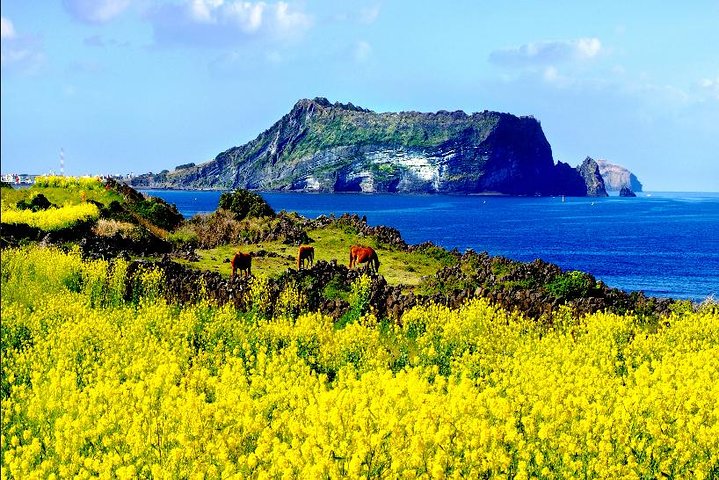
Jeju Island has been South Korea's domestic holiday destination for so long that the island's tourist infrastructure is now arguably the finest and most efficient in East Asia. The theme parks, the duty-free malls, the Olle walking trails — all excellent, all well-organized, all thoroughly visited by the 15 million annual tourists who make Jeju South Korea's most visited destination. The consequence is predictable: the famous places are famous, and the unfamous places are genuinely empty. Jeju is geologically and ecologically one of the most extraordinary islands in Asia — a UNESCO Triple Crown holder (World Heritage, Biosphere Reserve, Geopark) — and most of its geological and ecological treasures are known mainly to the island's own residents and to a small international scientific community.
The haenyeo (female divers) tradition, the volcanic geology of oreum cinder cones that dot the island's central plateau, the tangerine orchards of the eastern Seogwipo slopes, and the indigenous Jeju horse breeding community — all of these are available for discovery by anyone willing to get off the Hallasan-Manjanggul-Seongsan axis. The island is only 73 km across at its widest point; no destination is more than an hour away from any other. This makes Jeju the ideal place to combine famous and hidden in a single trip without logistical complexity.
These ten hidden corners of Jeju require a rental car or bicycle and the willingness to follow roads that aren't on the standard tour map. Many of the best experiences here are free, geological, and deeply Jeju in ways that the resort hotels are not.

1. Saryeoni Forest Trail (Mid-Week Dawn)
Saryeoni Forest Road (Bijarim-ro) is a 15-km forest track through the volcanic tableland of central Jeju, lined with Japanese cedar planted in the 1970s reforestation program and now forming cathedral-like canopy tunnels that block most direct light even at midday. On weekends it draws Korean photographers seeking the mist and light conditions. On a weekday at 7 AM, before any other visitors arrive, the forest is genuinely otherworldly: the cedar stands are at the right age to create a canopy height of 20-30 metres, the mist sits at ground level in autumn and winter mornings, and the only sound is the dripping of condensation from the canopy and the occasional roe deer moving in the undergrowth.
The geological context of Saryeoni is the reason the forest exists here: the central Jeju plateau is covered in basaltic lava flows from the main Hallasan volcanic edifice and multiple subsidiary cones, creating a soil structure that drains rainfall immediately into the volcanic substrate rather than forming surface rivers. The water table emerges at the coast through submarine springs rather than rivers — Jeju has no natural rivers above ground. This drainage pattern means the tableland forest has a specific moisture regime that creates the mist and the specific plant community that the photography community has discovered.
Saryeoni Forest Road starts from the Bijarim parking area off Route 1112 in the central plateau. Drive from Jeju City (30 minutes) or Seogwipo (35 minutes). The entrance is free. Walking the full trail length and back takes 3-4 hours; driving through (permitted) takes 30 minutes. Park at either end and walk from the centre for the most concentrated forest experience. The best photography conditions are autumn (October-November) mornings when the humidity is highest.
The forest trail passes several natural sinkholes (gotjawal) — the specific basaltic lava tube ecosystem unique to Jeju. These gotjawal are dense, tangled lowland forest growing on porous lava fields that stay cooler than the surrounding landscape and support plant species not found elsewhere in Korea. The Gwaneumsa Route of Hallasan also passes through gotjawal forest in its lower sections. The combination of cedar forest (human-created) and gotjawal (volcanic-created) in the same 15-km corridor makes Saryeoni one of the most ecologically diverse trails on Jeju.
2. Olle Trail Section 10 (Hwasun)
The Jeju Olle Trail is 437 km of walking path around and across the island divided into 26 sections. Section 10 between Hwasun and Moseulpo on the southern coast is the least-visited of the coastal sections despite containing the most geologically dramatic coastal landscape on Jeju: the Hwasun Columnar Joints (a UNESCO Geopark site) where perfectly hexagonal basalt columns emerge from the sea cliff like a natural pipe organ. These columnar joints were formed when lava flows cooled slowly enough to create systematic fracturing — the same process that produced the Giant's Causeway in Northern Ireland, but with columns averaging 2 metres in diameter and extending 20 metres above the sea surface.
The Hwasun columns are viewable from above (from the cliff path on Olle 10) and from below (by scrambling carefully down to the base at low tide — the footing is excellent on the flat column tops). At low tide, the column tops form a natural pavement at sea level where the rock pools between columns contain goby fish, sea urchin, and the specific sea life of the volcanic tide pool ecosystem. This is where haenyeo dive for abalone and sea cucumber — the column base pools are known foraging grounds.
Drive or bus to Hwasun beach (30 minutes from Seogwipo). The Columnar Joints site is signposted from the Hwasun parking area. Entry free to the geological site. The Olle 10 section begins here and continues 15.6 km to Moseulpo — walkable in one direction with a bus return. The best time to see the columns is 2 hours before and after low tide (check the Korean tide table app). In the evening, the black basalt columns and the silver sea surface create the best possible monochrome landscape photography available on Jeju.
The Moseulpo end of Olle 10 has the Jeju Airline Aviation Museum and the Sagyeseok cliffs — another UNESCO Geopark feature where lava tubes were cut by coastal erosion to create sea arches and caves. The combination of geological sites along this single trail section makes Olle 10 the most geoscience-rich walking day available on Jeju, and its low visitor count (compared to the famous Seongsan Ilchulbong sunrise or the Manjanggul tube) makes it feel genuinely exploratory.
3. Haenyeo Village in Udo Island
Udo Island, accessible by a 15-minute ferry from Seongsan pier, is the only inhabited island off Jeju and has its own haenyeo community — the female divers who have been harvesting the sea floor around Jeju since at least the 1st century CE. The haenyeo on Udo are older on average than those on the main island (the Udo community skews 70s-80s as younger women chose different careers) and the diving culture here is less performative than on Jeju proper because there are fewer tourists on Udo. Watching a haenyeo group dive from the eastern coast of Udo — they work in pairs and threes, each dive lasting 1-2 minutes, the women surfacing and doing the specific whistle exhalation called sumbisori that decompresses the air in their bodies — is witnessing a living practice without touristic mediation.
The Udo coast where haenyeo dive is the northeastern tip (Dongamssalcome Beach) and the area around the lighthouse. The diving happens when conditions are right — no fixed schedule, dependent on weather and season. October and November are the most active months before the winter cold reduces the diving season. Simply being on the right beach at the right time (early morning, before 10 AM) is usually sufficient. There's no barrier between the haenyeo work and the beach; respectful watching from the shore is normal.
Ferry from Seongsan Pier to Udo: every 30 minutes, 3,000 KRW one way. A single day on Udo is sufficient for the whole island — the perimeter is 17 km and can be cycled in 3 hours (rental at Udo pier, 10,000 KRW per day). The haenyeo deotbat (dining hall on the pier) serves the haenyeo's morning catch as seafood bibimbap and raw sliced abalone for lunch from 11 AM — the freshest abalone available on Jeju because it was in the sea two hours before. 20,000-30,000 KRW per person for a full seafood set.
Udo's landscape is different from Jeju proper: lower, greener, agricultural, with peanut fields and a famous black peanut ice cream tradition. The Udo lighthouse on the northeast tip (open daily 9 AM to 5 PM, free) has a 360-degree view of the surrounding sea including Seongsan Ilchulbong visible across the strait. The island's original fishing village on the western coast (Cheonjin Port) has been preserved essentially unchanged from the 1960s — the low stone houses with corrugated iron roofs and the stone walls between properties are the most authentically old-Jeju architecture accessible to visitors.
4. Sanbangsan Mountain and Sanbanggulsa Temple
Sanbangsan is a dome-shaped volcanic plug on Jeju's southern coast — not part of the Hallasan volcanic edifice but a separate intrusive rock body pushed up through the Jeju lava field approximately 800,000 years ago. The Sanbanggulsa temple cave is built into the natural cavity in the cliff face at 150 metres elevation, reachable by a 20-minute steep walk from the base. The cave is an active Buddhist shrine with a spring that drips from the cave ceiling — believers say it is the tears of the mountain goddess Sanbang-deok, who was rejected by Hallasan. The spring, geologically, is groundwater from the volcanic aquifer emerging through natural cave seeping.
The geological and mythological explanations coexist comfortably on Jeju, and at Sanbangsan the combination is more compelling than either alone. The view from the cave mouth at 150 metres takes in the entire southern Jeju coast from Moseulpo to Seogwipo — a panorama that includes Hyeongje Island (the "Brother Islands") offshore and the UNESCO World Heritage volcanic landscape of the Seogwipo coastal UNESCO site. The haenyeo of the southern coast can sometimes be seen diving in the sea directly below the cave at a distance of perhaps 500 metres.
Sanbangsan is on the southern coast road Route 1120, accessible from Seogwipo in 30 minutes by car or bus (Line 755). Entry to the trail: 1,000 KRW. The base area has a small temple complex and a sand beach (Yongmeori Beach) below the cliff — a striking basalt coastal formation accessible at low tide through a trail system below the mountain. Combine Sanbangsan (morning) with Yongmeori Beach (afternoon low tide) for the complete geological picture of the western Jeju volcanic landscape.
The interior of Sanbangsan is technically inaccessible — the dome is solid rock with no interior cave system (unlike the Manjanggul lava tube on the island's north). But the base of the mountain has natural formations visible from the path that show the cooling history of the volcanic plug: hexagonal jointing in the basalt surface of the dome, different from the horizontal columnar jointing of the coastal cliffs. Jeju's geology is not background — it's the content, and Sanbangsan is one of the places where that content is most easily read.
5. Biyangdo Island's Crater Lake
Biyangdo is a tiny island (0.59 sq km) off the northwestern coast of Jeju, accessible by a 15-minute ferry from Hanrim Port. The island has a single volcanic cone (Biyangbong, 114 metres) with two craters — the only volcanic island off the coast of Jeju, formed about 1,000 years ago in one of the most recent eruptions in Korean geological history. The island has 650 residents, three restaurants, no accommodation, and a walking trail that circles the base (3 km, 1 hour) and climbs to the crater rim (additional 45 minutes). The outer crater contains one of the few permanent ponds on Jeju — fed by the specific rainfall collected inside the bowl topography.
The population of Biyangdo is entirely fishing-dependent — the island is inside one of the richest sea cucumber and abalone grounds on Jeju's north coast, and the women of Biyangdo (traditionally all haenyeo) still maintain the diving tradition. The ferry to Biyangdo is the only transport; arriving on the first ferry (usually 9 AM) and leaving on the last (usually 4-5 PM) provides enough time for the full crater walk and a seafood lunch at the pier restaurant. The ferry service is weather-dependent in winter and canceled when seas exceed 2 metres.
Ferry from Hanrim Port: twice daily in summer, once daily in winter. 7,000 KRW return. Drive to Hanrim from Jeju City (35 minutes) or Seogwipo via the western coast road (45 minutes). No advance booking required for the ferry; arrive 20 minutes before departure. The pier restaurant at Biyangdo serves fresh-caught sea cucumber soup (haesam tang) and raw crab (gaejang) — local specialties at local prices (15,000-25,000 KRW) rather than tourist prices.
The crater rim view from Biyangbong covers the full northwest Jeju coast with Hallasan visible to the southeast and the open sea to the northwest — one of the finest panoramas accessible from any Jeju hiking summit, achieved in 45 minutes from the ferry landing. The inner crater pond is habitat for migratory waterbirds in spring and autumn: little grebe, mallard, and common teal regularly use the isolated freshwater in the middle of the sea. The combination of geological formation, bird habitat, and human community is specifically Biyangdo and specifically Jeju in a way that the mainstream tourist sites, for all their quality, are not.

6. Jeju National Museum
The Jeju National Museum, in the northeastern quadrant of Jeju City near the Samseong Shrine, is the finest repository of Jeju archaeological and historical material and is visited by a tiny fraction of the tourists who come to the island for the natural sites. The museum's collection covers the neolithic period on Jeju, the Tamna Kingdom (the indigenous polity that preceded Korean unification in the 10th century CE), the Goryeo and Joseon period administration of the island, and the specific Jeju material culture — the haenyeo's diving equipment, the volcanic stone agricultural tools, the specific weaving traditions — that distinguishes Jeju from mainland Korean culture.
The Tamna Kingdom section is the most important and least-known. Tamna was an independent polity for approximately 2,000 years — it maintained tributary relationships with the Chinese mainland, the Japanese archipelago, and the Korean kingdoms while retaining its own king, language, and cultural identity. The Tamna language is extinct but its traces survive in Jeju dialect, in place names, and in the specific cosmology that produced the haenyeo diving tradition, the volcanic stone grandfather figures (dol hareubang), and the shamanic religion (musok) that still operates alongside Korean Buddhism on the island.
The museum is on 17 Illo 1-gil, north of the city center. Entry free. Open Tuesday to Sunday, 9 AM to 6 PM. Allow 2 hours minimum. The outdoor sculpture garden contains original dol hareubang (the basalt grandfather figures that are Jeju's emblem) and vernacular stone artifacts from the island's farming past. The museum café serves jeju tea and traditional jeju mandu (dumplings with specific island fillings) — the best museum café food in Jeju by some margin.
The Samseong Shrine (Samseonghyeol) adjacent to the museum is the founding myth site of Tamna: three holes in the ground from which the three founders of the Tamna Kingdom are said to have emerged from the earth — the first mythological event in Jeju's human history. The site is maintained by the descendants of the three founding families and the spring rites are still performed annually. The holes are visible in the site, cordoned by stone fence, surrounded by ancient trees. The mythological simplicity and the continuous maintenance over 2,000 years make it one of the most quietly extraordinary heritage sites in South Korea.
7. Olle Trail Section 14-1 (Jeju City West)
Olle Section 14-1 from Jeju International Airport along the north coast to Hallim is the hidden urban section of the Olle network — it passes through the fishing communities of Ildo, Samdo, and the coastal areas of western Jeju City that most visitors drive through without stopping. The coastal path here passes working boat yards (where the local fishermen maintain their sampan-style vessels using techniques unchanged since the 1960s), sea wall fishing spots where elderly Jeju men fish for mullet in the early morning, and the Gangjeong Village area that became famous in the 2010s as the site of the protest against the Jeju Naval Base construction.
The Gangjeong Village section of the trail includes the haenyeo diving grounds on the coral reef system that was partially protected and partially damaged by the naval base construction — a contemporary environmental and political story that the Jeju tourism narrative carefully avoids. The Gangjeong Peace Center in the village is run by community activists and displays the history of the 8-year protest (2007-2015) through photographs, documents, and personal testimonies. Entry free. Open by appointment through the village community organization.
The full Section 14-1 is 18.3 km, taking 5-6 hours at a comfortable pace. Start from Jeju City airport area (bus from city center) and end at Hallim, where the bus back to Jeju City runs frequently. No entry fees. The trail is marked with the blue and orange Olle ribbons throughout. The western end near Hallim passes through the Hallim Park area (entry 11,000 KRW, a garden park with volcanic cave access) and the Hyupjae and Geumneung beaches that are Jeju's finest swimming beaches on the north coast and significantly less crowded than the eastern beaches near Seongsan.
The north coast fishing villages on this section serve raw fish (hwe) at the pier restaurants from 11 AM at prices below the restaurant district: 30,000-40,000 KRW for a full raw fish platter (jeongsik) including sides, soup, and rice at the fishermen's pier shack restaurants versus 60,000-80,000 KRW at the same portion in the Jeju City restaurant strip. The difference is ambiance (plastic chair versus interior dining) and a zero-markup relationship between boat and plate.
8. Donnaeko Valley Walk
Donnaeko Valley, on the southern slope of Hallasan in the Seogwipo area, is the access route for the Donnaeko Hiking Course on Hallasan — one of the two routes to the summit crater. The lower valley section (below the Wonangpokpo Falls area) is accessible without hiking boots and provides the finest forest river walk on Jeju: a narrow valley with clear water pools, waterfalls, and the specific Jeju subtropical forest canopy (Japanese camellia, laurel, and subtropical fern species that grow on the warm southern slopes below 800 metres) that turns the valley walls into a green corridor even in winter.
The Wonangpokpo twin waterfalls — two 20-metre cascades side by side — are the valley's primary feature, accessible after a 2.5-km walk from the trailhead. They are visited primarily by Korean day hikers aiming for the Hallasan summit and not specifically by anyone interested in the valley's botanical and geological character. The trail to the falls passes naturally exposed sections of the original basaltic lava flow that the valley was carved through — the rock walls show the layered flow structure clearly, each layer representing a different eruption event in Hallasan's volcanic history.
Donnaeko Valley trailhead is 8 km north of Seogwipo city center on Route 1100. Bus from Seogwipo (Line 240). Parking available. Entry free. The flat lower section to the falls: 2.5 km, 1 hour. The full Donnaeko Course to the crater summit: 9.1 km, 4-5 hours. Open 5 AM to 2 PM (the cutoff time for reaching the summit and returning by closing at 5 PM). Weather at the summit is independent of sea-level conditions — check the Hallasan visitor information center forecast before attempting the summit.
The pools below the waterfalls at Donnaeko are swimming spots used by local residents in summer — safe, cold (sourced from the volcanic aquifer at the mountain's interior), and surrounded by subtropical forest that makes Donnaeko feel tropical in a way that the northern Jeju coast never does. The southern slope microclimate (warmer, more humid) supports the breadfruit, camphor, and wax myrtle species that the island's traditional craft industries used for furniture and tool handles. The gotjawal lava field forest at the valley's lower margins preserves this subtropical ecosystem in its most undisturbed form on Jeju.
9. Seogwipo Seafood Market (Early Morning)
Seogwipo has a functioning wholesale fish market at its port that operates from 5 AM daily, serving the restaurants and households of the city's southern coast community. This is not the tourist fish market experience (there are cafes and restaurants nearby that stage a tidier version) but the actual wholesale market where the night's catch from the local fishing fleet is priced and sold to buyers who arrive in small trucks. The variety of fish and seafood specific to the southern Jeju coast — hairtail (galchi), Jeju turban snail (boje), wild abalone, and the specific reef fish not found on the northern coast — makes this market a substantially different experience from the Dongmun market in Jeju City.
The Seogwipo port itself has a different character from the resort-facing aspects of the city: the working harbor with its fishing vessels, the net-mending operations on the pier, and the fuel dock where the fleet replenishes are the functional infrastructure of the economy that the island's food culture depends on. The haenyeo association office is at the port — the women who arrive to sell their morning dive catch to the market buyers represent the same tradition documented in the UNESCO Intangible Cultural Heritage listing, but in the actual commercial context rather than the demonstration setting.
Drive to Seogwipo New Port from the city center (10 minutes, free parking). The market is in the covered hall adjacent to the main pier. 5-8 AM is the wholesale phase; 8 AM onward is retail. The surrounding raw fish restaurants open at 9 AM and serve direct from the morning's catch. A full dolsot bap (stone pot rice) set with raw fish, seaweed soup, and assorted Jeju banchan (side dishes) costs 15,000-20,000 KRW per person at the pier restaurants. This is the meal that the island actually eats, not the tour bus version.
The Seogwipo city walking route south from the port leads to the Oedolgae Sea Stack (a famous basalt rock formation) and the coastal cliff walk to Jeongbang Waterfall — the only waterfall in Asia that falls directly into the sea. Both are technically tourist sites, but visiting them from the port after a 6 AM wholesale market experience, walking 15 minutes through the genuine residential neighborhood south of the port, creates a layered understanding of the southern Jeju coast that the car-and-parking approach cannot generate.
10. Jeju Haenyeo Museum
The Jeju Haenyeo Museum in Gujwa-eup on the island's northeast coast is the definitive institution for understanding the haenyeo tradition — a custom where women dive without SCUBA equipment to harvest the sea floor, a practice that has continued on Jeju and the nearby Udo Island for at least 1,500 years and was listed on UNESCO's Intangible Cultural Heritage list in 2016. The museum is well-funded and unusually well-organized for a Korean regional museum, with displays covering the haenyeo's equipment (wetsuit evolution from cotton to modern neoprene), their communal social structure (bulteok, the gathering place), the ecology they manage, and the oral tradition of haenyeo songs that accompanies the diving culture.
The most important exhibit in the museum is the documentation of the haenyeo's ecological management practice: the women's communities have self-regulated their harvesting for centuries, establishing closed seasons for specific species, rotational harvesting areas, and size limits — a community-based conservation management system operating entirely outside government regulation that predated modern fisheries science. The comparison between the haenyeo-managed reef areas (healthy, diverse) and the government-managed or commercially-fished areas adjacent to them is the most compelling argument for indigenous ecological knowledge in contemporary Korean environmental policy, and the museum makes this argument visually and effectively.
The museum is in Gujwa-eup on Route 1132, accessible from Seongsan (15 minutes) or Jeju City (45 minutes). Entry 1,100 KRW. Open Tuesday to Sunday, 9 AM to 5 PM. The attached outdoor area demonstrates haenyeo diving techniques through informational panels at the actual diving beach — watching real haenyeo dive (which happens at the nearby Hado beach when the weather and season permit) is the complement to the museum exhibits. The museum's gift shop sells haenyeo-designed textiles and ceramics that support the aging practitioners directly.
The Gujwa-eup area around the museum has the densest population of practicing haenyeo villages on Jeju. The morning diving sessions (visible from the coastal path between Gujwa and Hado between 7 and 10 AM in the spring-autumn season) involve organized women's groups of 20-50 divers working specific reef sections. The sumbisori whistle (the exhale sound haenyeo make when surfacing) carries for hundreds of metres on calm mornings. This sound — specific, extraordinary, eerie — is the sound of the most important living cultural tradition on Jeju Island.