
Okinawa is Japan's most ecologically and culturally distinct prefecture — and also its most misunderstood. The mainstream Okinawa travel experience is the beach resorts of the Chatan and Onna village coastlines, the American bases that dominate the central island landscape, and the Naha tourist circuit of Kokusai Street shopping and Shuri Castle. This version of Okinawa exists and is fine in its beach-holiday way. But Okinawa's actual identity — its Ryukyuan cultural heritage that predates Japanese annexation, its marine biodiversity that exceeds anywhere else in the Pacific north of Taiwan, its World War II landscape of tragedy and memory, and its community of centenarians whose longevity has been studied globally — is almost invisible to the resort tourist.
The Ryukyuan Kingdom ruled an independent state from Okinawa Island and the surrounding island chains for 600 years before Japan's 1879 annexation. The language, the music (sanshin string instrument, distinct from any Japanese music), the textile traditions (bingata fabric, Ryukyuan lacquerware), and the spiritual practice (Ryukyuan Utaki sacred site religion) are all distinct from Japanese cultural forms. They're also actively maintained by the current Okinawan community, not merely preserved as heritage. Understanding Okinawa as a distinct culture rather than a southern Japanese island changes the entire experience of being here.
These ten hidden corners of Okinawa Island require going south to the Battle of Okinawa sites, north to the Yanbaru forest, and underwater wherever the reef system is accessible. All of them reward the longer visitor who has time to get past the beach.

1. Yanbaru National Park's Northern Forest
Yanbaru (ヤンバル) is the forested northern third of Okinawa Island — a subtropical broadleaf forest that is the only habitat on earth for several endemic species, most famously the Okinawa woodpecker (ノグチゲラ, Sapheopipo noguchii, classified as endangered) and the Okinawa rail (ヤンバルクイナ, Hypotaenidia okinawae, flightless, found nowhere else on earth). The forest was designated Japan's newest National Park in 2016. The UNESCO World Heritage listing of 2021 (as part of the Amami-Ōshima, Tokunoshima, northern Okinawa island, and Iriomote island cluster) confirmed its international ecological significance. Most Okinawa visitors never go north of the Nago area.
The Okinawa rail has become an icon of Ryukyuan identity — the bird appears on the Okinawa prefectural tourism materials and in the Yanbaru National Park branding. Finding one in the wild requires early morning walks on the forest trails of the Kunigami area (the northernmost municipality of Okinawa Island). The rail is more often heard (a loud, far-carrying call at dawn and dusk) than seen, but patient walking on the Bise Forest Walk trail or the Yadambu Creek path increases sighting probability. The Yanbaru Wildlife Conservation Center in Kunigami village provides trail maps, species guides, and information on current sighting hotspots.
Drive north from Naha on the Okinawa Expressway to Nago, then Route 58 north to Kunigami (total 3 hours). There is no public transport to the remote forest trails. Rental car from Naha airport is essential (from ¥4,000 per day). The Yanbaru Wildlife Conservation Center is in the Higashi village area, open Tuesday to Sunday 9 AM to 5 PM (free entry). The best time for wildlife is October to April when the temperature is comfortable and the vegetation is less dense. Summer (June-September) is typhoon season and road conditions can be poor.
The Yanbaru forest also hosts the Okinawa habu (ハブ, Protobothrops flavoviridis) — a venomous pit viper endemic to the Ryukyu Islands and one of the most ecologically important predators in the forest system. The habu is the reason the Okinawan mongoose introduction (designed to control the habu population) went catastrophically wrong in the 1970s — the mongooses preferred eating endemic birds and reptiles rather than habu, and the mongoose is now the primary threat to the Yanbaru bird population. Signs throughout the Yanbaru forest indicate habu presence; wearing long trousers and watching where you step on forest trails is standard practice.
2. Okinawa Prefectural Peace Memorial Museum and Mabuni Hill
The Battle of Okinawa (April 1 to June 22, 1945) was the largest amphibious assault in Pacific War history and the bloodiest single battle in the Pacific theater. 110,000 Japanese soldiers, 12,000 American soldiers, and a minimum of 94,000 Okinawan civilians were killed in 82 days — one quarter of Okinawa's entire civilian population. The southern tip of Okinawa Island (the Mabuni area in Itoman City) is where the battle's final phase was fought and where the highest concentration of civilian deaths occurred. The Okinawa Prefectural Peace Memorial Museum here is the most important historical museum in Japan after Hiroshima's — it presents the battle from the Okinawan civilian perspective, which is substantially different from the American and Japanese military perspectives that dominate most Pacific War histories.
The museum specifically documents the Okinawan civilian experience: the "mandatory" suicide of communities who believed American capture meant torture (Japanese military propaganda was responsible for this belief), the "Blood and Iron Student Corps" of teenage boys mobilized to fight, and the "Himeyuri Student Corps" of high school girls mobilized as nurses who mostly died in the final American advance on the southern caves. These are specifically Okinawan tragedies — the mainland Japanese military experience was different, and the Japanese government's handling of this history has been contested by Okinawan communities and educators for decades.
Drive south from Naha on Route 331 to the Itoman Peace Memorial Park area (40 minutes). The museum entry is ¥300. Open Tuesday to Sunday, 9 AM to 5 PM. Allow 3 hours minimum — the audio tour (available in English) is essential for the contextual content. The Cornerstone of Peace outside the museum (a massive field of black stone tablets engraved with the names of all 240,000 people killed in the battle, arranged in a semicircle of curved walls) is the most powerful physical memorial to the battle. The tablets include the names of all nationalities — Okinawan, Japanese, American, Korean forced laborers — in a conscious non-nationalistic commemoration.
The Mabuni Hill cave system (south of the museum, accessible by walking trail) is where the Japanese 32nd Army headquarters was located during the final phase of the battle. The caves are accessible to visitors with torches; the wartime infrastructure (bunker walls, ventilation shafts, ammunition storage) is partially visible. The hill above the caves provides a view over the East China Sea that the Japanese commanders watched for the approaching American fleet. This is what it looks like — the view from the last defensive position of an army that knew it had lost.
3. Naha's Tsuboya Pottery District
Tsuboya is Okinawa's historic pottery district — a neighborhood in Naha that has been continuously producing Ryukyuan ceramic ware (yachimun) since the 17th century. The pottery tradition here (established by the Ryukyu Kingdom's government by consolidating kiln operations in a single district) produces the specific Okinawan ceramic aesthetic: warm reddish clay bodies, thick glazes in teal, cream, and dark brown, and the characteristic lion-dog (shīsā) roof ornament that is Okinawa's most ubiquitous protective symbol. The Tsuboya neighborhood retains several working kilns and the Yachimun no Sato (Pottery Village) in the district's western section has open kilns visible during firing days.
The Tsuboya Pottery Museum in the district center documents the technical and cultural history of Ryukyuan ceramics with unusual depth — the genealogy of kiln traditions from their Chinese, Japanese, and Southeast Asian sources, the specific glaze chemistry that produces the characteristic Tsuboya teal, and the political significance of the pottery tradition as a marker of Ryukyuan identity. Entry ¥350. Open Tuesday to Sunday, 10 AM to 6 PM. The museum's collection includes reconstructed Ryukyuan kiln models and a kiln archaeology section that shows the physical remains of the original 17th-century kilns preserved beneath the current neighborhood.
Tsuboya is 10 minutes walk southeast of Kokusai Street (Naha's main tourist street) — follow the ceramic tile street art markers into the district. The neighborhood's main lane (Tsuboya-yachimun Dori) has working pottery shops selling direct from the kiln — the prices are Naha retail rather than tourist souvenir prices. Genuine yachimun at these direct-from-maker shops costs ¥800-6,000 for a cup or bowl, versus ¥1,500-10,000 for the same or similar quality at Kokusai Street souvenir shops. The difference is simply geography.
The Tsuboya neighborhood's residential streets behind the main pottery lane have preserved the specific Okinawan vernacular house form that predates the concrete construction that dominates the rest of Naha. The traditional Okinawan house has a low, tiled roof with large shīsā (lion-dog pairs) mounted at the ridge ends, a stone perimeter wall (ishigantō) with an S-curve entry to deflect evil spirits, and the specific proportion of a house adapted for typhoon resistance in a subtropical climate. Finding these houses in the back streets of Tsuboya is easier than finding them anywhere else in Naha.
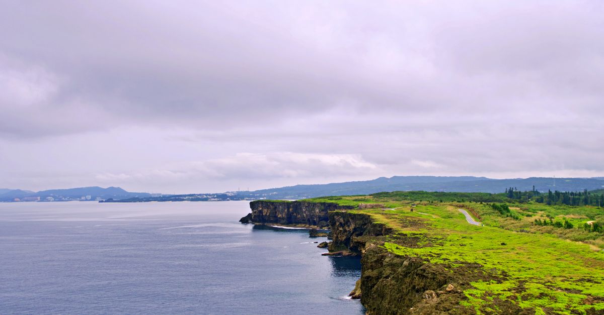
4. Cape Hedo's Northernmost Tip
Cape Hedo (辺戸岬) is the northernmost point of Okinawa Island — a cape of jagged limestone and coral cliff jutting into the junction of the Pacific Ocean and the East China Sea. The geology here is spectacular: the Ryukyuan limestone that caps most of northern Okinawa was deposited as ancient coral reef and has been uplifted by tectonic activity, creating the same cliff landscape found in the karst regions of southern China that produced the limestone towers of Guilin. At Cape Hedo, the cliffs drop 50-100 metres directly into the ocean on three sides, with the Amami Islands visible to the northeast on clear days.
The cape is the geographic conclusion of the northern Okinawa road and the starting point for the swimming, diving, and rock climbing community that uses the cape's coastal waters. The water color at Cape Hedo — deep indigo in the ocean channels, turquoise over the reef flat, and the specific peacock blue of the reef edge dropoff — is the most intense marine color spectrum visible from land anywhere in Japan. The natural pool formed in the limestone at the cape base (accessible by a path from the parking area) is filled by wave surge and warms to comfortable swimming temperature in the afternoon.
Drive north from Naha on the Okinawa Expressway to Nago, then Route 58 north to Cape Hedo (total 3.5 hours). No public transport. The cape is free to visit. The parking area has a single snack stand (Okinawan A&W is elsewhere; this is a home-operated shave ice and Okinawan soba stand) open from 10 AM to 4 PM. The Cape Hedo monument (marking the point) is photo opportunity level; the surrounding cliff walks are the real content. Go before 9 AM for the best light on the eastern sea face.
The waters directly below Cape Hedo are a known feeding area for whale sharks from April to June — they follow the Kuroshio Current north past the cape in spring. The cape also marks the boundary of the Okinawa humpback whale feeding grounds (winter, November-April). Standing at the cape with binoculars from November through April can produce spouts visible from the cliff within 200-500 metres of shore. This is not guaranteed but is common enough that the local fishing community monitors it and the Yambaru ecotourism operators time their whale-watching boat trips to depart from the cape area during peak season.
5. Nakijin Castle Ruins
Nakijin Castle (今帰仁城) on the Motobu Peninsula in northern Okinawa is a UNESCO World Heritage Site and one of the finest examples of Ryukyuan castle architecture. While Shuri Castle in Naha (recently rebuilt after a fire) is the more famous Ryukyuan castle, Nakijin is architecturally more interesting because it has never been rebuilt — the curved stone walls (built without mortar, using the specific Ryukyuan ratchet-fit technique of alternating large and small stones) are original 14th-century construction and have survived in better condition than any other Ryukyuan fortress. The walls follow the natural contours of the headland they were built on, creating an organic curved perimeter that is the defining visual characteristic of the Ryukyuan castle system.
The castle was the seat of the Hokuzan lord — one of the three kingdoms that divided Okinawa before the Ryukyuan Kingdom united the island in 1416. The site overlooks the Motobu Bay with views north toward Izena Island and east toward the Okinawa main island ridge. Cherry blossoms at Nakijin are famous in Okinawa because the castle's elevated northern exposure means the trees bloom in January — two months earlier than the mainland Japan cherry blossom season. The January cherry blossom festival at Nakijin is the earliest cherry blossom event in Japan.
Nakijin is accessible from Naha by bus (Okinawa Express Bus to Nago, then local bus 65 to Nakijin, total 2 hours, ¥1,900) or by rental car (2 hours from Naha airport). Entry ¥600. Open daily 8 AM to 6 PM (8 PM in summer). The castle's inner sacred area (noro shrine, where Ryukyuan priestesses conducted their rituals) is separate from the main fortification area and provides access to the undisturbed forest interior of the castle ridge.
The Motobu Peninsula surrounding Nakijin is the most interesting northern Okinawa destination cluster: the Churaumi Aquarium (world's second-largest aquarium, with whale sharks in the main tank), the Nakijin Castle ruins, and the Motobu strawberry farms (December to March, pick-your-own at ¥1,500 per person unlimited eating in the greenhouse) combine into a northern Okinawa day that covers marine biology, Ryukyuan history, and subtropical agriculture in a single circuit. It's also the best single day trip available from Naha for visitors with a single full day to spend outside the capital.
6. Okinawa's Oldest Sake: Awamori at a Distillery
Awamori (泡盛) is Okinawa's indigenous spirit — a distilled rice liquor that has been produced in the Ryukyu Kingdom since the 15th century, predating the introduction of Japanese shochu to the mainland. The production method is specific to Okinawa: black koji mold (which evolved in Okinawa's subtropical climate and differs from the white and yellow koji used in mainland Japanese sake and shochu) is used in single fermentation, followed by distillation to produce a spirit that typically runs 30-43% alcohol. The specific awamori character — earthy, deep, with a long finish — is the result of the black koji's distinct enzymatic activity.
The Zuisen Distillery in Shuri (the area around Shuri Castle in Naha) is the oldest continuously operating awamori distillery in Okinawa, founded in 1617 during the Ryukyuan Kingdom period. The distillery welcomes visitors for free tasting and tours of the production facility. The aged awamori (kusu, which means "old" in Ryukyuan) at Zuisen has been fermenting in Okinawan clay pots for up to 30 years — the oldest kusu releases (available in limited quantities at the distillery shop) develop a flavor complexity that approaches aged brandy rather than anything most spirits drinkers expect from a rice distillate.
Zuisen Distillery is in Shuri district, accessible by the Yui Rail monorail to Shuri Station (15 minutes from Naha Airport Station, ¥290) plus a 10-minute walk. Open Monday to Saturday, 9 AM to 5:30 PM. Free entry, free basic tasting, paid tasting of reserve products (¥500-1,000 for a flight of three). The distillery museum section documents the Black Koji (Aspergillus awamori) cultivation process and the clay pot aging tradition. Buy kusu (aged awamori) directly from the distillery rather than from the airport duty-free shops — the selection is broader and the price difference is 20-30%.
The awamori experience at Zuisen is best combined with a visit to Shuri Castle (the rebuilt Ryukyuan royal palace, entry ¥820, partially under reconstruction after the 2019 fire) and the Shuri neighborhood itself — the most architecturally coherent of Naha's historic areas, with surviving Ryukyuan stone walls and the specific garden aesthetic of the royal capital. The combination of royal palace, awamori distillery, and the Shuri neighborhood market (open daily along Shuri Kinjo-cho) covers Nara's Ryukyuan cultural heritage in a single morning.
7. Ryukyuan Utaki Sacred Sites
The Ryukyuan Utaki (御嶽) are sacred natural sites specific to the indigenous spiritual tradition of the Ryukyu Islands. They are not temples or shrines — they are natural spaces (cave mouths, large trees, rock formations, cliff edges) designated as the dwelling places of the gods (kami) of the Ryukyuan tradition. There are thousands of Utaki across the Ryukyu islands; the most important are UNESCO World Heritage sites. The Seifa Utaki (斎場御嶽) on the Chinen Peninsula in Nanjo City is the most sacred site in the Ryukyuan tradition — the place where the creation goddess Amamikiyo first set foot on Okinawa Island and where the Ryukyuan high priestess (kikoe-okimi) conducted the most important ritual of the royal court.
Seifa Utaki is a series of limestone formations on a forested ridge, approached through a sacred forest path and reaching three distinct ritual spaces: the first chamber (a triangular space formed by two leaning limestone rocks), a platform with sea view toward Kudaka Island (the sacred island where the gods live), and the deepest inner sanctum (the Sanguu), accessible through a narrow passage. The site has no buildings, no human construction — the sacred space is defined entirely by natural formation and by tradition. Women of the Ryukyuan noro (priestess) tradition still conduct private rituals here; the public path allows visitors to experience the atmosphere without entering the restricted ritual areas.
Seifa Utaki is 50 km south of Naha in Nanjo City, accessible by rental car (1 hour) or by bus from Naha Bus Terminal (Line 38 to Chinen, 1.5 hours, ¥830). Entry ¥300. Open daily 9 AM to 6 PM. The forest approach through the limestone karst vegetation is 30 minutes each way. Go in the early morning before tour groups arrive. Wear long trousers (the forest path can be muddy) and respect the designated restricted areas absolutely — the Utaki tradition requires that certain spaces remain unvisited by non-practitioners.
Kudaka Island, visible from Seifa Utaki and known as the "Island of the Gods" in Ryukyuan tradition, is accessible by ferry from Chinen Port (30 minutes, ¥1,630 return). The island is inhabited by approximately 200 people and has no roads accessible to rental cars. Bicycle rental at the ferry landing (¥500 per day) covers the island's 8-km circumference. The sacred tradition on Kudaka is maintained by the resident noro community — the island's spiritual practices are not accessible to tourists but the island landscape, the traditional houses, and the sea view back toward Okinawa Island (where Seifa Utaki is visible on clear days) provide the geographical and atmospheric context for the Ryukyuan creation mythology.
8. Itoman's Fishing Village
Itoman at the southern tip of Okinawa's main island is primarily known as the location of the Peace Memorial Park. The city's actual identity as Okinawa's most important fishing port is almost entirely unknown to tourists. Itoman's Fishermen's Festival (Haarii, held in late May on Dragon Boat Day) is the most important traditional maritime festival in the Ryukyu Islands — a competition between long, low dragon boats paddled by fishing community crews that has been held here for over 300 years. The festival is attended primarily by Okinawans and is one of the most culturally specific events accessible from Naha.
The Itoman wholesale fish market at the southern port operates from 4 AM, selling the night's catch from the Itoman fleet. The Itoman fishermen use a specific net technique (tingusha) for offshore reef fish that produces catches of the specific subtropical species that Naha's finest restaurants source exclusively from this market. The market is not tourist-facing but is accessible to visitors who arrive at 4-6 AM and observe without impeding the buying process.
The Itoman fishing port is accessible from Naha by bus (30 minutes, ¥400) or car. The wholesale market is at the port building south of the main commercial area. No entry fee. The Itoman traditional boat-building workshop (accessible through the Itoman Fisheries Cooperative, advance arrangement required) shows the construction of the Sabani — the traditional Ryukyuan dugout fishing boat that has been the primary small fishing vessel in Okinawa for 2,000 years. The Sabani-de Coast to Coast Race (an annual event from Zamami Island to Naha, approximately 40 km) uses traditional Sabani and draws paddlers from across Japan and internationally.
The Itoman area south of the port has the densest concentration of traditional Okinawan shīsā (roof lion-dog ornaments) visible from public roads in all of Okinawa. The residential neighborhoods here have maintained the traditional house form with more consistency than the rest of southern Okinawa's concrete replacement construction, and the combination of shīsā on every ridge, the stone perimeter walls, and the subtropical vegetation creates the most representative traditional Okinawan residential landscape accessible from the main island road.
9. Katsuren Castle and Uruma Bay
Katsuren Castle (勝連城跡) on the Katsuren Peninsula is the best-preserved Ryukyuan castle in its natural setting — the walls climb directly from a limestone sea cliff to the highest point of the headland, with Uruma Bay visible on both sides. The castle was the seat of Amawari, a 15th-century Ryukyuan lord who challenged the Shuri royal authority and whose political story is the basis for multiple Okinawan stage plays and novels. The castle was abandoned after the Ryukyuan unification and has been a ruin since the 16th century — the natural weathering of 600 years has created a moss-covered, plant-invaded ruin aesthetic that the reconstructed Shuri Castle cannot match.
The site was excavated in the 2010s and produced an unexpected finding: medieval European and Chinese coins mixed with the Ryukyuan artifacts, suggesting that the Katsuren domain was conducting its own independent maritime trade with Chinese and possibly Southeast Asian and even Middle Eastern merchants, bypassing the Shuri royal trade monopoly. This archaeological evidence confirms that Katsuren was a rival trade center rather than simply a rebellious vassal — the political story of Amawari is an economic story about who controls the maritime trade route.
Katsuren is accessible from Naha by rental car (50 minutes) or by Okinawa Bus to Uruma City and then taxi (total 1.5 hours, ¥1,000). Entry ¥600. Open daily 9 AM to 6 PM. The castle interpretation center at the base has an unusually well-designed display of the excavation findings and the maritime trade evidence. The climb to the castle's upper terrace is 20 minutes on a stone path and produces the finest panoramic view of the Katsuren Peninsula, the offshore Uruma Bay island chain, and the open Pacific beyond the reef. Bring water — the climb is hot in summer.
The Uruma Bay offshore islands — Hamahiga, Henza, Miyagi, and Ikei — are accessible via the bridge network from the Katsuren Peninsula and constitute a half-day exploration of the small island ecology of the inner Ryukyu system. Hamahiga Island is the oldest inhabited island in the Ryukyuan tradition (the creation goddess Amamikiyo is said to have first descended here before stepping onto the main island at Seifa Utaki). Ikei Island has the finest beach in the Uruma area. The circuit of the four islands by rental bicycle from the Henza bridge takes 3-4 hours and passes through communities that are genuinely remote-feeling despite being 50 km from Naha.
10. Blue Cave Snorkeling at Maeda Point
Maeda Point (真栄田岬) on the west coast of Okinawa Island, 30 km north of Naha in Onna Village, is the most accessible point on the island for encountering the offshore reef system. The specific Blue Cave (青の洞窟) at Maeda Point's southern cliff base is entered through a narrow sea cave whose opening creates a specific light-filtering effect when the sun angle is right (10 AM to 2 PM in summer): the water inside the cave turns an intense electric blue from the reflection of external sunlight entering the cave mouth and scattering off the white sandy bottom. The color is specific to this cave's geometry and orientation and is not reproducible by any other means.
The Blue Cave is accessed by snorkeling from the Maeda Point beach platform (a rough descent from the parking area, manageable with care) or from a boat tour. The snorkeling approach is better: you swim along the cliff face for 200 metres from the beach platform, enter the cave mouth, and experience the interior for 10-15 minutes before the cave becomes crowded. Arrive at the platform by 9 AM and enter the cave by 9:30 AM to beat the boat tour groups that arrive from 10 AM onward. By 11 AM the cave is occupied by tour groups and the experience degrades significantly.
Maeda Point is accessible from Naha by rental car (45 minutes) or by Okinawa Bus to Onna Village (1 hour, ¥750). No snorkeling equipment rental at the point itself; rent from one of the dive shops in the Onna Village resort area 3 km south (¥1,000-2,000 for a set). Entry to the Maeda Point parking area is free. The cliff descent to the water platform requires caution in wet conditions; wear water shoes or sports sandals with grip.
The marine life at Maeda Point beyond the Blue Cave is the best argument for this location outside the cave's famous visual effect. The outer reef edge at 5-8 metres depth (accessible by snorkeling for anyone comfortable in deeper water over the reef edge) supports a coral community of extraordinary diversity: table Acropora coral, brain coral colonies, sea fans, and the specific shallow-reef fish community of the Ryukyu Islands (damselfish, wrasse, parrotfish, and the iconic Nemo clownfish in anemone homes on the reef face). The reef at Maeda has been protected from net fishing since 1970 and shows the recovery capacity of a protected tropical reef over fifty years — it looks like the reef systems that were everywhere in the Ryukyus before industrialized fishing arrived.


